


Bushfire Information for Residents
Total Fire Bans and Fire Danger Ratings
- Details
Total Fire Bans (TOBAN)
A total fire ban is declared because of extreme weather conditions. They are declared on days when fires are most likely to spread rapidly, threaten lives and property and be difficult to control. A TOBAN is usually declared the afternoon before to ensure that they are based on the most accurate weather forecasts. It usually starts at midnight and lasts 24 hours.
When a TOBAN is declared it is illegal to do anything that could or is likely to start a fire. The ban includes all open fires for the purposes of cooking and camping and all fire permits are suspended.
To find out when Total Fire bans have been declared check NSW Rural Fire Service Fire Information - Fire Danger Ratings and Total Fire Bans.When a TOBAN has been declared, signs are placed by your brigade at the top of the Zig Zag, Mt Wilson Station, Cathedral Reserve and Happy Valley.
Fire Danger Ratings
The Fire Danger Rating (FDR) is an assessment of the potential fire behaviour, the difficulty of suppressing a fire and the potential impact on the community should a bushfire occur. It is an early indicator of potential danger and should be your first trigger for action.
The FDR is determined by the Fire Danger Index (FDI). The FDI was developed at CSIRO in the 1960s to measure the degree of danger of fire in Australian forests. The FDI is a combination of air temperature, relative humidity, wind speed and drought. An FDI of 1 (Low-Moderate) means that the fire will not burn, or will burn so slowly that it will be easily controlled, whereas an FDI in excess of 100 (Catastrophic) means that the fire will burn so fast and so hot that it is uncontrollable. The FDI is calculated by the Bureau of Meteorology (BOM) for each region. Mt Wilson and Mt Irvine are included in 'Greater Sydney Region'.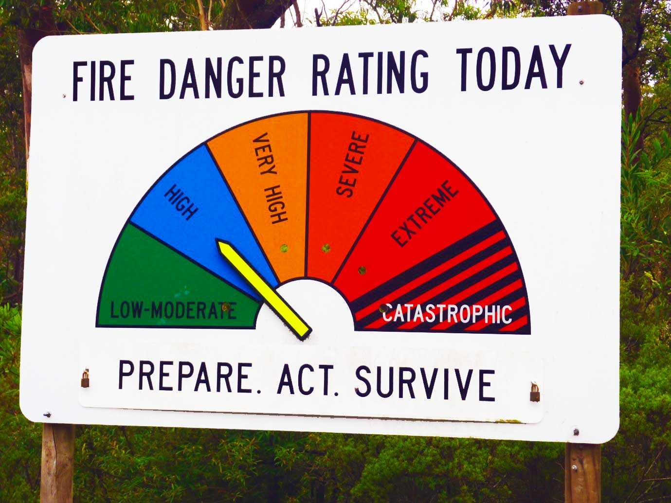
| Rating | Index |
| Catastrophic | 100+ |
| Extreme | 75-99 |
| Severe | 50-74 |
| Very High | 25-49 |
| High | 12-24 |
| Low to moderate | 0-11 |
The conditions of the Black Friday fires of 1939 were used as the example of a 100 rating. The Black Saturday fires of 2009 reached ratings of 120 to 190. There is also an index for grasslands.
The Fire Danger Meter (FDM) has become an icon of rural Australia as most towns have an FDM on their outskirts. The FDM for Mt Wilson and Mt Irvine is located outside the Mt Wilson fire shed.
For further information of Fire Danger Ratings check the NSW Rural Fire Service website under Plan and Prepare - Fire Danger Ratings.
Street Coordinators
- Details
The Mt Wilson/Mt Irvine Rural Fire Brigade has established a network of Street Coordinators who have volunteered to assist both the brigade and local residents/property owners in the event of a significant fire threat.
The Street Coordinators are on hand to give other residents as much local information as possible to help them make their decisions. In addition, the Coordinators will update the Brigade on the whereabouts and intentions of people in their area and the conditions at their property to assist the Fire Services in prioritising their operational plans.
When fire threatens, please contact your local Street Coordinator to advise them of your situation. Street Coordinators will be regularly updated with the progress of any fire and should be your first port of call for obtaining local information. If you have a rental property, please advise tenants of the bushfire risk as well as advising the street coordinator of their existence and intentions.
Once the fire threat is over please contact your street coordinator to advise your situation or your return to Mt Wilson or Mt Irvine. Your Street Coordinators are:
| Area | Location | Street Coordinators |
|---|---|---|
| 1 | Mt Irvine | Bruce Kerridge |
| 2 | Mill Rd, Wynnes Rocks Rd, Hollyridge, Noonameena, Killaloo | Alice Simpson, Johanna Renton |
| 3 | Queens Ave, Wyndham Ave and The Avenue (Breenhold to Milparra), Waterfall Rd, Wynstay | Anne Pigott, Deb Griffin |
| 4 | Church Lane, The Avenue (Hay Lane to Mt Irvine Rd) | Barbara Landsberg, Janet McDonald |
| 5 | Mt Irvine Rd (Wollartukkee to The Old Mill), Hillcrest Lane, Galwey Lane, Davies Lane, Shadforth Rd, Beowang Rd, Lambs Hill |
Brenda Ainsworth, Richard Beattie, Alex Halliday |
| 6 | Farrer Rd East & West, Smiths Rd, Field Selection | Bruce Arnold, Judy Tribe |
Living with Bushfire at Mt Wilson & Mt Irvine
- Details
Welcome to living at Mt Wilson & Mt Irvine! Most people choose to live here for lifestyle reasons – they love the peace and quiet, the charm of the villages and their well-maintained gardens and the beauty and fascination of the flora and fauna of the surrounding bush. There are opportunities to pursue hobbies such as gardening, entertaining or bushwalking or just having a break from the buzz of work and city life.
In time you will realise that there are some lifestyle changes that you weren't expecting but are necessary for dealing with those particular challenges of living in the upper Blue Mountains such as leeches, wombats and power outages. The biggest lifestyle change from living in the city comes with the awareness that you now live in one of the most bushfire prone areas in the world and that it is your responsibility to take action to protect yourself, your loved ones and your property.
To best understand the impact that fire could have on your property you can look at the pdf Bush Fire Survival map (3.58 MB) under Community Protection Plans on this website. This shows, on a day of catastrophic fire conditions, whether your house will be impacted by direct flame, radiation heat or embers. In these conditions nowhere in Mt Wilson is guaranteed to be safe. It is hoped that maps for Mt Irvine will be available in 2014.
To assist you to best prepare for and survive a bushfire emergency, the brigade has developed a plan for all residents to follow. We call it the '7 Habits of Highly Effective Bushfire Survival Planning'. The use of the word 'habit' is quite deliberate as this plan now needs to become a regular part of your life in the Mounts. The 7 habits are:
- Write a Bushfire Survival Plan
- Prepare Your Property
- Know the History of Fire at Mt Wilson & Mt Irvine
- Understand Fire Behaviour
- Recognise Fire Danger Days
- Act When Fire Threatens
- Review & Rehearse Your Plan Before the Bushfire Season
Please take time to read through each habit and, most important of all, act on these recommendations to give yourself, your family and your property the best chance of surviving a bushfire.
The NSW Rural Fire Service website is a great source of information on all aspects of dealing with bushfires and provides the latest information on any incidents. If you would like to learn more about bushfire behaviour and strategies for dealing with such emergencies you could do no better than Join the Brigade. Your contribution to the safety of our community will be rewarding and greatly appreciated.
Community Protection Plans
- Details
As a result of the tragic 2009 fires in Victoria, the NSW Rural Fire Service has embarked on a program of developing Community Protection Plans for vulnerable towns and villages in NSW. Mt Wilson was chosen to be part of the trial as an example of a village located in a heavily forested area with only one access road. The plan was completed by NSW RFS staff with assistance from the Mt Wilson/Mt Irvine Rural Fire Brigade. Data for a plan for Mt Irvine is currently being collected with the hope that a draft will be available in 2014.
The overall aim of the Community Protection Plans is to 'improve community and fire fighter capacity to prepare, act and survive bushfires'. The Plan consists of three maps:
-
- Operational Brigade map (for Brigade only) – provides brigades and other fire fighting agencies with important operational data such as fire trails, water supplies, community assets, helipads, communication towers, neighbourhood safer places etc
- pdf Bush Fire Preparation map (5.22 MB) – provides information for land managers, fire agencies and the community on details of existing and proposed bush fire risk treatment works for the community. It shows past and planned hazard reduction works
- pdf Bush Fire Survival map (3.58 MB) – the most interesting map for residents as it provides vital information for preparing a Bushfire Survival Plan such as indicating the possible impact on your property of a fire as well as leave early options and neighbourhood safer places.
The Bush Fire Survival Map shows the effects of a fire (direct flame, radiation heat or ember attack) when the Fire Danger Rating is 'catastrophic' and fire is coming from all directions. This is an extreme case and one not yet experienced here (since white settlement). Nevertheless, bushfire conditions do not need to be 'catastrophic' for fires to destroy properties and lives. The Fire Danger Rating at the outset of the 2013 State Mine Fire was 'extreme' and that fire destroyed 2 properties and numerous sheds, fences and equipment and came close to burning all round Mt Wilson and Mt Irvine. The map is extremely useful for showing you the worst case scenario for your property as well as last resort options.
For further information on Fire Danger Ratings check the subtopic on this website or the NSW RFS website under Plan and Prepare – Fire Danger Ratings.
Hazard Reductions and Pile Burns
- Details
Hazard Reductions
Under the Rural Fires Act, 1997, land managers and owners are responsible for carrying out hazard reduction to protect existing dwellings, major buildings or other assets susceptible to fire. Effective hazard reduction is one way to reduce the risk of damage to homes and structures by bushfire. The RFS Commissioner has the authority to order all owners and managers of private, commercial and government land to conduct essential hazard reductions.
Agencies such as National Parks, State Forests and local Council reduce hazards on their property according to strategies in the Bush Fire Risk Management Plan put together by the Blue Mountains Bush Fire Management Committee.
Private landholders or occupiers must also reduce hazards on their property. If hazards are not reduced, the RFS can issue a notice (Section 66) requiring a private landowner or manager to reduce fuel loads.
The RFS offers advice and assistance on hazard reduction. RFS volunteers often do hazard reduction work to help protect their communities, but it is not their legal responsibility to do so, because the RFS does not own or manage land. Volunteers work with private landholders, National Parks, State Forests and NSW Fire Brigades to do hazard reduction on a range of land tenures.
To learn more about hazard reductions click on the NSW Rural Fire Service website.
To learn more about past and planned hazard reductions at Mt Wilson click on the Community Protection Plan - pdf Bush Fire Preparation map (5.22 MB) on this website
In Mt Wilson and Mt Irvine private properties rarely require large scale burns to reduce hazards. For residents here, reducing the risk of bushfire is mainly achieved by maintaining cleared space around the house and properly maintaining the garden. This can result in a pile of dead vegetation (a bushfire risk) and, if it cannot be chipped, mulched or taken to the tip, the best way to dispose of it is to undertake a pile burn.
Pile Burns
The restrictions that are now placed on the burning off of garden waste are mainly an attempt to control pollution. In the Blue Mountains this is the responsibility of Blue Mountains City Council and generally pile burns are not allowed
After community consultation, the BMCC has granted certain outlying areas (including Mt Wilson and Mt Irvine) approval to conduct pile burns as long as certain conditions are met. Oversight of this process has been handed to the NSW Rural Fire Service. It is vitally important that these conditions are abided by as failure to do so could see the withdrawal of this concession. During the non-bushfire period (usually 1 April to 30 September) the process, in brief, is as follows:
- Norify and apply online for approval to conduct a pile burn. This can be done via the RFS here.....
- Give your neighbours at least 24 hours' notice of your intention to light up.
- There is a requirement for a responsible adult to be present at all times, an adequate water supply to be available and the pile must be 20m from the nearest residential building.
- Ensure that your pile burn abides by the document Standards for Pile Burning, available from www.rfs.nsw.gov.au. In brief, material must only be vegetation from your property, the pile should be no greater than 2m in length or width and must be no greater than 1.5m high, material must be dead and dry and no logs over 150mm in diameter.
During the bushfire season (usually 1st October to 31st March) the increased risk of bushfire means that any pile burns allowed also require a permit from the District Office of the NSW Rural Fire Service. As this entails an inspection of your pile it is preferable that you give a fortnight to complete the process. Permits can be given for up to 21 days but they are usually given for a lesser period. In the event of a TOBAN (Total Fire Ban) all permits are revoked. See the Blue Mountains District NSW Rural Fire Service website for more details.
Your local brigade will do their best to protect properties in the event of a fire but they cannot be everywhere. You need to give your property the best chance of surviving on its own and being able to protect you and your family. Even if your brigade can get to your street, if they have to choose between properties, crew safety dictates that they will have to choose the better maintained and safer property to protect. So, please:
GIVE US A BREAK – ALONG YOUR BOUNDARY, AROUND YOUR HOUSE AND WATER SUPPLY AND THROUGH YOUR PROPERTY ENTRANCE
Bowens Creek - Emergency Access Campaign
- Details
EMERGENCY FIRE TRAIL ACCESS
BILPIN TO MOUNT IRVINE AND MOUNT WILSON
PLEASE PHONE OR WRITE TO THE PEOPLE BELOW
This is an update on behalf of the Mt Wilson/ Mt Irvine Rural Fire Brigade as lead community organisation on this issue.
Blue Mountains City Council (BMCC) passed a Motion on 28 March reaffirming its commitment to working with Hawkesbury City Council (HCC) on a joint project to restore the route as an emergency vehicles access route. That positions BMCC to work with HCC to access the Federal Government’s 2016 Election commitment to provide $100,000. That funding will allow BMCC and HCC to undertake a feasibility study and costings so that they will be positioned to seek further funding for the restoration works.
We have received strong support in this from all our Ward One Councillors, Kerry Brown (who lodged the Motion), Kevin Schreiber and Don Mc Gregor as well as from Mayor Mark Greenhill. That support extends to them reaching out to the HCC counterparts to seek their support for this project which will benefit both BMCC and HCC community groups.
We are advised that BMCC and HCC Council Managements are already in communication to progress this and that there are also meetings planned between Mayors and Councillors.
To support and provide assistance to BMCC and HCC, we are also obtaining further information on how BMCC and HCC can access the $100,000 through an application process to the Federal Department of Infrastructure and Regional Development.
Federal Member for Macquarie, Susan Templeman MP continues to provide support and has made representations to Minister Fiona Nash, Minister for Regional Development and Minister for Local Government and Territories, who is now responsible for this Federal Government support for type of regional infrastructure project. Minister Nash is a Senator for New South Wales.
We also continue to encourage the RFS Blue Mountains District to pursue this with Hawkesbury RFS District. We continue to note that the Brigade and community are not advocating that the route be restored as a public road. Rather, we see its strategic value as a piece of infrastructure for fire hazard reduction work (not firefighting) and access for ambulance and police rescue vehicle when Mt Wilson Rd is not available due to severe weather and fire events and helicopters are not able to fly or are unavailable due to competing demands.
It’s worth remembering that our Brigade plays a role in many types of non-fire events, such as assisting other authorities in motor vehicle accidents and rescues as well as undertaking emergency clearing of fallen trees where they block roads along our only access route of Mt Wilson Rd and around the two villages. Our Brigade is also the home of our NSW Ambulance First Responders group which works with the Ambulance Service to provide initial emergency medical assistance in our isolated location.
As we do play this broad role in supporting all our emergency services as well as Blue Mountains City Council, we are also looking to engage with the Blue Mountains Emergency Services Committee to raise awareness and support for the restoration of this route as an important piece of local infrastructure for a variety of emergency situations.
In past updates we have asked residents, our visitors and all interested parties to write to BMCC, HCC, State and Federal Ministers and local Members to urge them to cut through any cross- jurisdictional impediments and restore the route as a fire trail for emergency vehicles.
While we’ve made a lot of progress on this in the last year, we need to keep working at it. So, even if you’ve already written, please write again. And if you haven’t done so, please let our various levels of government know of your support for this. It may be your life or the life of a loved one which is saved through the availability of this route in emergency circumstances.
Contact details are provided below. The people to contact:
|
The Hon Gladys Berejiklian MP Premier GPO Box 5341 SYDNEY NSW 2001 8574 5000 |
The Hon D F Perrottet MP Treasurer, and Minister for Industrial Relations GPO Box 5341 SYDNEY NSW 2001 8574 6900 |
|
The Hon Troy Wayne GRANT MP Minister for Police, and Minister for Emergency Services GPO Box 5341 SYDNEY NSW 2001 This email address is being protected from spambots. You need JavaScript enabled to view it. 8574 6900 |
Susan Templeman MP Member for Macquarie (includes Blue Mountains) PO Box 855 Windsor NSW 2756 This email address is being protected from spambots. You need JavaScript enabled to view it. 4573 8222 |
| Trish Doyle MP
Member for the Blue Mountains 32 Macquarie Road NSW 2777 4751 3298 |
Cr Mark Greenhill OAM Mayor - Blue Mountains City Council KATOOMBA NSW 2780 This email address is being protected from spambots. You need JavaScript enabled to view it. 0414 195 990 |
|
Cr Chris Van der Kley Deputy Mayor Locked Bag 1005 KATOOMBA NSW 2780 This email address is being protected from spambots. You need JavaScript enabled to view it. 0427 805 810 |
Cr Kevin Schreiber BMCC Locked Bag 1005 KATOOMBA NSW 2780 This email address is being protected from spambots. You need JavaScript enabled to view it. 0431 501 981 |
|
Cr Don McGregor BMCC Locked Bag 1005 KATOOMBA NSW 2780 This email address is being protected from spambots. You need JavaScript enabled to view it. 0434 306 143 |
Cr Kerry Brown BMCC Locked Bag 1005 KATOOMBA NSW 2780 This email address is being protected from spambots. You need JavaScript enabled to view it. 0414 195 980 |
|
Mr Robert Greenwood General Manager BMCC Locked Bag 1005 KATOOMBA NSW 2780 This email address is being protected from spambots. You need JavaScript enabled to view it. |
Mr Peter Conroy General Manager Hawkesbury City Council This email address is being protected from spambots. You need JavaScript enabled to view it.
|
|
Councillor Mary Lyons-Buckett Mayor - Hawkesbury City Council PO Box 25 Kurrajong NSW 2758 This email address is being protected from spambots. You need JavaScript enabled to view it. 0419 512 192 |
Councillor Barry Calvert Deputy Mayor PO Box 146 Windsor NSW 2756 This email address is being protected from spambots. You need JavaScript enabled to view it. 4567 7478
|
|
103 The Terrace This email address is being protected from spambots. You need JavaScript enabled to view it. |
Councillor Patrick Conolly PO Box 146 Windsor NSW 2756 This email address is being protected from spambots. You need JavaScript enabled to view it. |
Councillor Amanda KotlashPO Box 14
This email address is being protected from spambots. You need JavaScript enabled to view it. |
Councillor Sarah RichardsPO Box 3136
This email address is being protected from spambots. You need JavaScript enabled to view it. |
Councillor John Ross1A Fairfield Ave This email address is being protected from spambots. You need JavaScript enabled to view it. |
Councillor Peter Reynolds10 Bridge St This email address is being protected from spambots. You need JavaScript enabled to view it. |
|
Councillor Paul Rasmussen PO Box 146 Windsor NSW 2756 This email address is being protected from spambots. You need JavaScript enabled to view it. |
Councillor Danielle Wheeler
This email address is being protected from spambots. You need JavaScript enabled to view it. |
|
Councillor Tiffany Tree Windsor NSW 2756 This email address is being protected from spambots. You need JavaScript enabled to view it. 0434 021 610 |
Councillor Nathan Zamprogno332 Saunders Rd This email address is being protected from spambots. You need JavaScript enabled to view it. |
|
Mr David Jones District Manager Rural Fire Service Blue Mountains This email address is being protected from spambots. You need JavaScript enabled to view it.
|
Mr Matt Lawrence Editor Hawkesbury Gazette This email address is being protected from spambots. You need JavaScript enabled to view it. |
|
Mr Damien Madigan Editor Blue Mountains Gazette |
|
Hazard Reduction Guidelines
- Details
FireWise communities experience fewer fires and fewer fire-related deaths, injuries and property losses.
We encourage all property owners to review their own properties and we are willing to offer advice on the various alternatives, although the final plan is your responsibility.
Fire can be a useful tool for reducing bush fire hazards, removing rubbish or conducting agricultural activities. The inappropriate use of fire however, can endanger lives, property and the environment.
Property owners carry an important community responsibility to ensure all the area within their property boundaries has been properly prepared for a bushfire and that they have protected their own and their neighbour's properties. They can do this by hand clearing, carrying out hazard reduction activities on their properties before a fire season begins. This can be by slashing bush to lower the fuel loads particularly under trees, removing flammable material, or by controlled burning.
The following guidelines are provided to assist you, the landowner and/or contractor to comply with the conditions required by a notice issued under Section 66 of the Rural Fires Act. By carefully following these simple instructions, your obligation as a member of this community will not only be met, but the balance between bush fire safety and environmental responsibility, will be maintained.
Bulldozing or clearance of the block to bare earth is not acceptable. Unless otherwise specified, all trees covered by Council's Tree Preservation Policy are to be retained. Severe penalties are applicable for acts of environmental degradation. The use of bulldozers, other track type machinery or skid steer loaders is not acceptable except to load logs, stumps and heaps onto trucks for transport to Council garbage tips. Rubber tyred wheel type agricultural tractors with slashers, walk-behind mower slasher, scrub cutters and hand tools are the most satisfactory equipment for clearing on the fragile soil types of the Blue Mountains. Only this type of minimum impact equipment is approved for use.
The understorey vegetation from about 50mm above ground level should be cut, thinned, removed or mulched. Single specimens or groups of plants not exceeding 3 square metres in area may be left in an undisturbed condition provided a break of at least 3 metres is maintained between these islands. By this method both habitat and species diversity will be maintained whilst the overall fire threat will be reduced. Where possible such islands should be located around retained semi-mature trees.
Small saplings and vegetation under the proportions specified by Council's Tree Preservation Policy may be removed, lopped or thinned (preference should be given to smooth barked species when retaining trees). As stated earlier the removal of any tree covered by Council's Tree Preservation Order requires Council inspection and approval.
Cut vegetative material and ground fuel, leaves, bark, twigs, grass tussocks etc. may be mulched and spread over the block to help prevent weed invasion and soil erosion. Such mulch must not exceed 100mm in depth or 50mm square in size. Additional care must be exercised on steep slopes, near watercourses and swamp areas. Once the land has been cleared, no material is to be heaped and left. The work on the block and therefore compliance with any notice issued will not be considered complete until this process has been finalised.
If material is heaped during the clearing process, it must be disposed of by one of the following methods, removal to the local garbage tip or by returning it to the site in the form of mulch. Burning is not recommended and will only be permitted subject to all of the usual restrictions and conditions. Written permission for the use of fire to reduce fuel levels on privately owned land is required in all cases and subject to approval.
In addition to any specific requirements listed under environmental considerations in the notice, all legislation regarding protected and endangered species and pollution control must be complied with.
Should you have any uncertainty regarding your particular property or the requirements of any bush fire notice please contact Blue Mountains Fire Control Centre in Katoomba on 02 4784 7444. Your co-operation is sought in providing a safe and enjoyable environment on the Blue Mountains.
We ask all property owners to review the material on the NSW RFS website to assist you to prepare yourselves and your property.
Various approvals may therefore be required before you light a fire. These approvals contain conditions that seek to minimise possible adverse impacts.
The following information will help you work out which approvals you need before you light your fire.
The Rural Fire Service (RFS ) can provide you with the following approvals (or advise you who to contact):
- Fire Permit - for fire safety; and/or
- Bush Fire Hazard Reduction Certificate - for bush fire hazard reduction works.
- Other government authorities may provide you with other environmental approvals.
You will need information before lighting a fire for hazard reduction on your property.
A great deal of published guidance is available and together with necessary approvals.
