


Outside the Village or towards Mt Irvine
Happy Valley
- Details
Allow one and a half hours from the Happy Valley Picnic Area. This is not an easy walk.
This is a special place, but it is a steep walk to get there. Opposite the Happy Valley picnic area there is a track leading into the valley. A large tree has fallen across the track but this can be negotiated and you quickly come into the rainforest where the tall straight trunks of the towering coachwood are a grand sight. After about 5 minutes walk the track divides and you take the left hand one.
(a) Happy Valley This is a well made track, but not much used. It winds down to Waterfall Creek, passing through some wonderful rainforest and massive rock covered rocks. It gets quite steep toward the bottom and is very slippery, so care must be taken. Once into the stream you will see a small waterfall which falls into a pond on your left. One can get down to this by crossing the stream directly above the fall. You will find little foot notches carved into the rock and you can clamber along the rock shelf and jump onto the rocks below. The pool is lovely for a quick cool dip. It is a good walk for the summer and is a lovely quiet secret place, well worth the effort of getting there.
(b) Cathedral Creek The right hand track also continues through the beautiful rainforest to the little creek which runs down from the Cathedral Reserve. Although the creek is often dry here, huge tree ferns grow and it is another lovely quiet place.
Boronia Point
- Details
Allow one and a half hours from the junction of Farrer Road West.
Walk or drive to Farrer Road West, which is about a one and a half kilometres beyond the Cathedral of Ferns. Farrer Road goes up the hill, but you take the fire trail on the left which wanders out along a ridge. It eventually comes to a wonderful area above the Wollangambe, and on the way you pass some lovely bush. You can walk right to the edge of the cliff and look into the river where it makes some spectacular S bends. In October and November when the wild flowers are out it is very lovely, and an easy walk.
Bogey Holes
- Details
Allow two or three hours.
This can be done two ways:
(a) Ryans's Cutting - This is the tight downhill corner about two miles from the village towards Bells Line of Road, beyond the Zig Zag and the gravel pit. Leave the car off the road and walk down the fire trail to your right (going out towards the main road). At the bottom of the slope, the main fire trail takes aright hand turn. But you go across a little creek here and follow an old and rather indistinct fire trail out to the Bogey Holes.This ends up in an area known as the Bogey Holes. From here you can explore - walk up the hill nearby or over the ridge and into the creek beyond. Then return the way you came.
(b) Sunday Walk Spur - Walk down Du Faurs Rocks Road and through a gate on your left on to the Western fire trail. Follow the fire trail to Sunday Walk Spur. Walk down the hill across the creek and you will eventually come out on to the fire trail from Ryan's Crossing. Cross the stream on your right and follow the track out to the Bogey Hole area. You can return either way, but it is nice to leave a car at Ryan's Cutting for an easier way home! The country out there, especially if you climb onto the ridge, is rather heath-like and open. Quite different and a nice change.
Zircon Creek
- Details
Two and a half hours.
This is another lovely little walk. Drive out toward Mount Irvine to Zircon Creek. It is on a broad but tight corner and you can park there on the left. Just before the corner, there is a small track going off to the right which you can follow. Go right to the gate to see the view east as it is rather nice. Return along the track for about 200 yards. After the open area where the track takes a curve to the left you will notice a small old logging trail going off to your right. This will take you down some lovely mountain ash to Zircon Creek and there is a delightful area of rainforest, lilli pilli, coachwood and sassafrass. Follow the track and it eventually brings you back to the Mount Irvine Road just past Lindfield Park, so that you return to the car by the road. Please take care walking on the narrow Mt Irvine Road.
It is an excellent walk, not difficult and passes a variety of bush. The boronia and mint bush at the beginning of Zircon Creek are well worth a visit in October. It is head high and that small area is nature's wonderland.
The Pavements
- Details
Three to four hours. There is a good picnic place at the end of the track.
Drive to the end of the Mount Irvine Road, through the gate and leave the car near the big tree in the turning circle. Walk along the fire trail (closing the gates please) and another fire trail comes in on the right. Quite soon you will see a small grassy area on your left and the path goes off here. The path takes you out to the Pavements, but if you lose it, keep up on top of the ridge and you will come back on to it. The Pavements, a tessellated hill, are interesting rock formations and you will come to them if you keep up on top of the ridge.
It is a wonderful place with superb views of the Wollangambe on your left and Bowens Creek on your right and the 'never never' of the wilderness. It is not a difficult walk.
The Wollangambe
- Details
Six to eight (6-8) hours.
Canyoning is a strenuous day. Getting to and from the canyon requires a descent and ascent of over 300m on a track that is steep and rocky in places. The entry / exit tracks require an exposed climb on tree roots.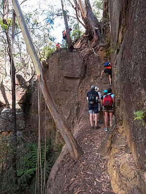
The canyon involves many long, cold swims, for which lilos and wetsuits are recommended, and there is a significant amount of climbing up, down and around house-sized boulders.
The exits may be hard to identify and can easily be missed. Parties need to ensure that all members are capable and know what the day entails.
The path commences behind the Mount Wilson Fire Station and is well worn as hundreds of people use it in summer. Follow the well worn path and you will be right. About a kilometre from the Fire Station there is a sign where the track down the hill leaves the fire trail. It leads down through a lovely rough bush with good views till you come to a stand of rocks. The path divides here and you go between the rocks to the left. (If you go on the right hand track you end up at the top of the canyons and it is difficult to get down). Walk along the spur and then over the top and you will see that the river is on both sides of you. Again the path divides:
(a) Upstream: Go down the track to your left and picnic at 'the beach'. You can then clamber up along a rough track upstream on the right until to the junction of the Bell Creek and the Wollongambe River. You cross there and again walk up into a wonderful ravine on your right. Walk on the left hand side of the river where you can walk beside the water. It is rather awesome and well worth exploring. But take care on slippery rocks!
(b) Downstream: If you take the right hand track you soon come to the river. Take off your shoes and follow the river down to the start of the canyons. There are some lovely cliffs and nice sandy stretches of river.
(c) Lilo-ing: A lovely thing to do on a hot summer's day, but it is not easy and one must take great care. It takes three hours from the top of the canyons to the exit, mostly on lilos, but one has to carry them around rocks in some places so one has to be fit and agile. Wet suits are very useful or a warm jumper as one gets very cold. It is an hour's steep climbing walk from the exit and this includes a climb up a small cliff face. It is best to do this activity with some who has already done it before or go with an organised group.
(d) Precautions:
- It is a full day activity. Expect to take 6 to 8 hours; up to 10 hours for bigger or slower groups.
- Make sure you are prepared to spend a night in the canyon, either to stay with an injured party member or due to running out of daylight.
- Make sure those at home have a realistic time of return and are prepared for the group to be out overnight without unnecessarily calling in emergency services
- There is only patchy mobile coverage at the top and no coverage in the canyons.
- Know what track you are on and what canyon you are doing
- It can take 3 to 4 hours for rescue parties to reach injured people.
(e) Gear required:
- Carry a PLB (Personal Locator Beacon) to give location if injured or lost. Please only set off if genuine injury or life at risk.
- Map and compass, plus be able to navigate in and out of the canyon. Do not rely on mobile phones for maps as they are of no use when flat or wet.
- Gear needs to be waterproofed in dry bags or a number of sealed garbage bags
- Head torch, first aid kit and matches
- Lilo, plus wetsuit or thermals for in the water
- Warm dry clothing (thermals & woollen jumper or fleece)
- Suitable footwear for both walk in and walking in the water/canyon (good grip)
Bush Run Course
- Details
Two hours one way
The Mount Wilson - Mount Irvine to Bilpin bush run was an annual event with over two hundred and fifty runners taking part. (Note that this run is no longer held as it crosses Bowens Creek bridge which was badly damaged by storms and has not been repaired to date).
The first section of the run is from Silva Plana, along the Northern fire trail, over Lamb's Hill and then up Farrer Road West.
The section described here is from Farrer Road East to the end of Danes Way on the top of Mount Irvine. The Bush Run continues along Mount Irvine Road and the Bowens Creek to Bilpin.
This walk starts at Farrer Road East where one can leave the car. If you have two cars, drive out to Mount Irvine to the far end of Danes Way and leave a car there.
Walk towards Mount Irvine and follow the power lines down the slope. About 200 metres down, there is a cairn of rocks and a small track going off to your right.
It is worth walking all the way down the slope to the creek. Crossing it and following the track to the end for about 15 minutes. Integral Energy have done a great job ensuring they can reach all power poles for service. It is pretty down there and one can see the far power pole across the gully which you pass later in the walk.
Return to the cairn of rocks and walk along the little track. A short steep climb up some steps takes you up to the power pole you saw earlier across the valley. Pause here and enjoy the view back towards Lindfield Park and Gowan Ross, and think of the difficulty the crews had in 1962 in putting the electricity across this gully when taking the power out to Mount Irvine.
This section of the walk has been made by Bill Ross who was a long keen long distance runner and who lived at the property Brambil at Mount Wilson for a time. It was he who suggested the Willy to Billy Bush Run (as it is now called) be put on the runners' annual calendar. Bill worked out the 34.4 kilometre course that borders on, and passes through the World Heritage listed Wollemi National Park.
Follow the electricity service road up the hill until you come to the level area. Turn left at the next track junction and left again at the next track out to the poles. Follow the power lines right and go up a rise and into the property Touri. The first fire trail around Touri branches off on the left on the first rise.
Follow the fire trail around Touri and you will eventually come out on the Mount Irvine Road. Turn left on to the road and start up the steep incline. Soon you will see a small track heading off on the left up the hill. This leads to Danes Way where again you turn left up the hill, past the public cemetery and onto the top of Mount Irvine. A lovely level walk along past Carisbrook beneath the tall trees takes you to the end of the road.
Bowens Creek Road
- Details
Allow 4 hours
This road was built during the the Depression and opened in 1935 after much persuading by the Mount Irvine residents for a second access road to their mountain. It goes from Mount Irvine to the Bells Line of Road at Bilpin just west of the small BP garage and store.
It is a narrow road which is cut into the cliff side on three levels on the southern side and winds it way up on the northern slope with three big hairpin bends. The effort by the men who built the road with very primitive tools was enormous and their living conditions would have been very rough, using rock shelters and tents.
The road on the south side has now sadly been closed to vehicular traffice from both the Biplin and Mt Irvine sides.
We are hoping it may be made into a fire trail in the future.
You can leave a car at either end of the road but it is a long car shuffle.
The gravel dump opposite the Rutherglen gate on the Bowens Creek Road is the start. Walk down the road, enjoying the bush as you go. After the first hair pin bend, and down a little, watch out for an inscription carved on the rock "1½ miles start of road", the letters of the 'S' being reversed in both cases. The carving is high on the embankment about four metres on a rock shelf on the top side (right going down) of the road.
After the second hairpin bend, there is a great view down over the creek valley and across to the three levels of the road on the other side.
As the road descends, the vegetation changes from open eucalyptus forest to rainforest near the creek. One of the old rock rock shelters used by the road builders can be accessed on the left and at some of the culverts where water falls on the rocks on the right, many glow worms can be seen at night.
Once down at Bowens Creek, wander up a little beside the creek or have a dip in the clear cool water or a picnic on the bridge.
The walk continues up on the southern side. On the top level, much vegetation clings to the rocky cliffs and you get a great view across the valley. If you are returning the same way, walk up the road as far as you want before retracing your steps. Otherwise continue along the road to you vehicle besides the Bells Line of Road.
