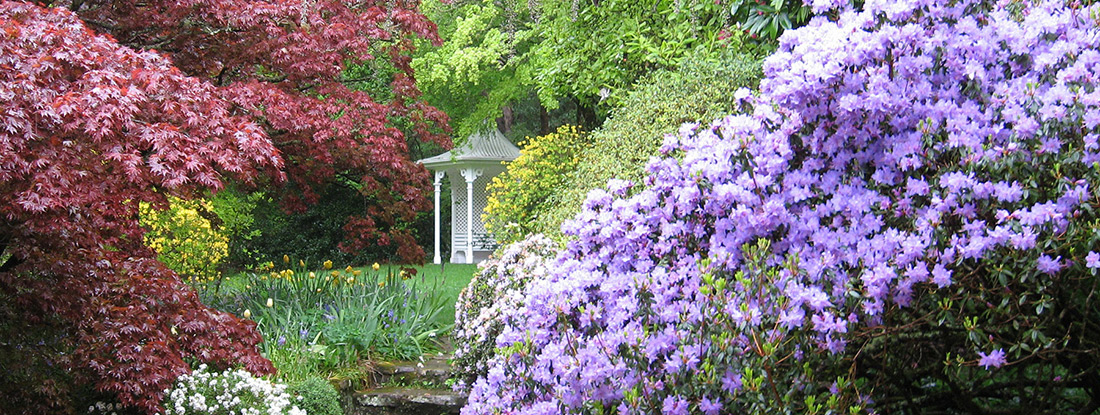
The Mt Wilson Village Walks
The Walks of Mt Wilson
- Details
The Walks of Mt Wilson
The Mt Wilson Village Walk
- Details
Allow 3 hours return, 2 hours if you just walk without many pauses.
The Village Walk was made in 2004 by the Mount Wilson Progress Association to encourage walkers to walk on the verge beside the road, rather than on the narrow roads throughout the village.
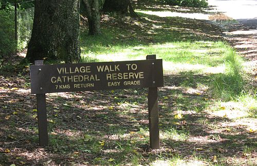
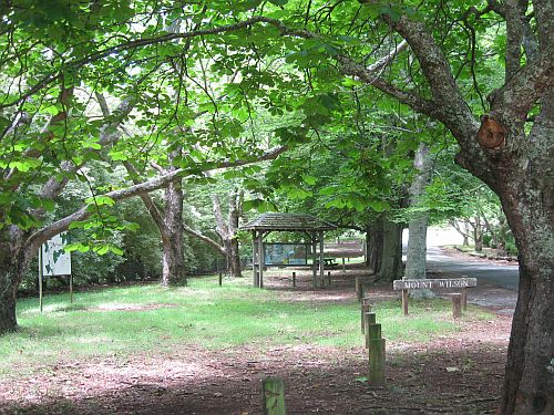
The Village Walk goes from just in front of Breenhold (near the entrance to Silva Plana) to Cathedral Reserve or in the reverse direction. It is about 3.5 km long but is an easy walk with gentle grades. It passes many of the points of interest in Mt Wilson. It includes the Anniversary Walk past Wynstay and also the walk entitled 'A walk along the Avenue'. It can be done in its entirety or just portions of the Village Walk can be selected. If the full length is walked, it is advisable to park a car at the far end unless a 7 km walk is planned. If you intend to start the walk at Cathedral Reserve it is suggested going to the end of this article for the start.
-

The Village Walk from Breenhold to Cathedral Reserve
If the Village Walk is started on The Avenue from outside Breenhold (opposite Silva Plana) the walk is on the left side of The Avenue towards the Fire Station and Village Hall.
Walking past Breenhold which is on both sides of The Avenue for much of this portion, you will come to Marcus Clark Reserve at the end of Breenhold. You can walk through Marcus Clark Reserve and experience the type of bush which is growing on sandstone and is atypical of the rainforest for which Mt Wilson is known.
A little further on, the road on the left is to Du Faurs Rocks and Chinamans Hat and a detour can be made to see this wonderful lookout. At this intersection is the Mt Wilson Fire Station and opposite is the Mt Wilson Village Hall.
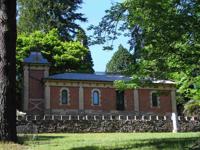
Continuing along the Village Walk past the Fire Station is a little bridge over a culvert and on the far side is the Old School House and the Old Teachers Cottage which together the Study Centre. Until 1987 these were the Public School and teachers cottage.
A little further on along The Avenue is the Mt Wilson, Mt Irvine and Bell War Memorial built in 1919 after the First World War. Continuing along the walk there are some old rhododendrons and a patch of rainforest and near the exit of the rainforest is Sloan Reserve on the opposite side of The Avenue.
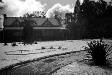
Continuing along the walk on the left side of The Avenue you walk past Nooroo, one of the well known gardens in Mt Wilson where the original entrance onto The Avenue has recently been restored. Just past Nooroo is Withycombe and opposite is Bebeah.
Bebeah and Withycombe
Both these houses represent the first European settlers in Mt Wilson. Both were built for descendents of William Cox, the builder of the road across the Blue Mountains in 1815.
Edward King Cox served in the NSW Legislative Council from 1874 until his death in 1883. In 1878 he bought 30 acres of land in Mt Wilson and built Bebeah to a design by Ambrose Thornley Junior. This was a fine country house with a massive central fireplace of brick and an 8 foot wide verandah all around. The garden had sweeping driveways, English shade trees and masses of flowers. In 1902 the Sloan family bought Bebeah from the Cox estate and this family remained the owners until the death of their youngest daughter, Marjorie in 1984. Marjorie Sloan was a great benefactor in the community and her name is perpetuated in the Sloan Reserve which she gave to the community in c.1960.
Withycombe (originally Beowang c.1919)
George Henry Cox, Edward King's cousin, after 1875 purchased land at the corner of The Avenue and Church Lane. Here he had built between 1878 and 1880 a substantial house Beowang (possibly an Aboriginal name for one of the tree ferns in Mt Wilson). The original building had a main gabled roof contained within symmetrical chimneys and a verandah overlooking spacious gardens with a tennis court where local people gathered.
Just past Withycombe is Church Lane on the left and just down Church Lane is Wynne Reserve.
Wynne Reserve at the corner of Church Lane and the Avenue
This small reserve was given by Jane (nee Wynne) and Bill Smart in the early 1970's, following the tradition established by Colonel Wynne, Jane's father. It was also given to maintain open space beside the Church.
On the The Avenue at the intersection of Church Lane is St Georges Church.
St George's Church
Henry Marcus Clark came to Mt Wilson in the first decade of the 20th Century. Following his unexpected death in 1913 the Clark family funded the building of the Church to be a Memorial to Henry Marcus Clark. Again Colonel Wynne provided the land on which the Church stands.
The massive trees and undergrowth on the block were cleared with a bullock team, while the tree ferns were preserved. The building material was transported from Bell Railway Station. Fibro was the choice; Henry Marcus Clark had been most interested in this new building material. He admired its lightness, its ease of construction and its resistance to fire was another vital quality.
The walls are fibro with battens to cover the joins. The roof too is fibro cut into tiles, painted and then nailed carefully. The inside of the roof is lined with Baltic pine from Northern Europe and the structural timbers are Oregon from North America. It is believed that the windows were made in Sydney and there is a fine stained glass window dedicated to Henry Marcus Clark. The pressed tin surrounds at the base of the building were popular at the time as a cheap imitation of sandstone.
The Church was consecrated in 1916 and is now included in Blackheath Parish. It is open on the second Sunday of each month for a 3.00pm service. Residents from Mt Wilson and Mt Irvine support and maintain it.
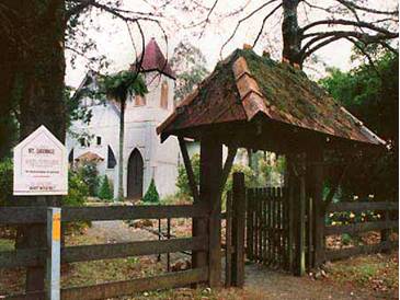
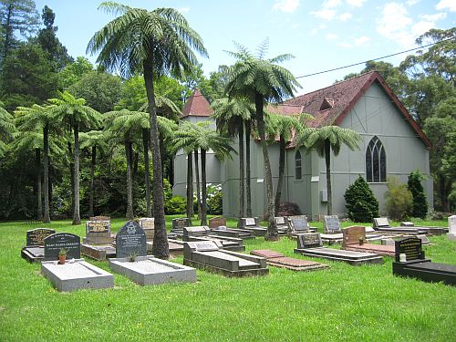
Continue along The Avenue past St Georges Church and you will see the cemetery in the church grounds (feel free to wander through the church grounds).
The Cemetery
Here are many familiar names: Wynne, Gregson, Clark, Kirk and many others. Many residents who have left Mt Wilson choose to have a plaque placed beneath a tree in their memory when they pass on.
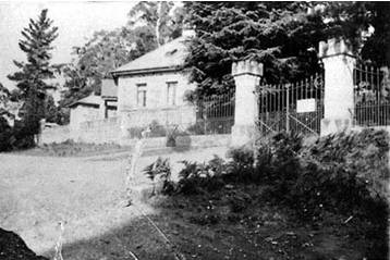
Just further on adjacent to the cemetery is the Post House.
The Post House
This building goes back to the early 1920's. From 1890 until 1921 the Post Office had operated in a small rustic building in the grounds of Withycombe. It was decided by local residents to donate the capital required to form a private company. Colonel Wynne donated the land, about 1 acre in area and the building was designed by a well known architect of that time, John Moore. From 1922 until 1986 it was used for the purpose for which it was built. In its early days it included a small tearoom, even acting as a small general store. All this time it was also the telephone exchange and it became an important centre for the village community. In 1986 all that changed when the phones became automatic and the Post Office closed. The property was sold and converted sympathetically into a cafe. A cafe operated here until 2003 when it became a private residence.
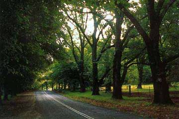
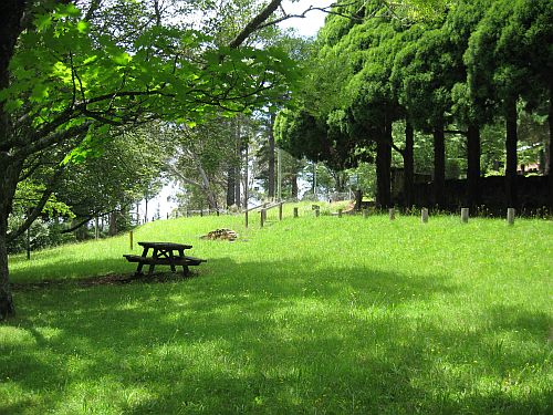
The Avenue from St George's Church to Founders Corner is seen as one of the main areas of Mt Wilson. It is here that visitors frequently park to enjoy the beauty of the trees, to catch a glimpse of spectacular gardens and to picnic or just enjoy the peace and tranquility. Picnic tables have been placed here by the local community for the benefit of visitors.
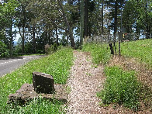
Past the Post House at the intersection of The Avenue with Mt Irvine Rd is Founders Corner.
Founders Corner
This corner was set aside from land given by Lieutenant Colonel Richard Owen Wynne, grandson of Richard Wynne, in 1932. Today it contains a basalt seat with a plaque carrying the names of the original settlers. The plaque was unveiled in 1968 as part of Mt Wilson's Centenary celebrations.
Read the plaque to the founders of the village on the stone seat then across Founders Corner and walk up the steps opposite the Wynstay Gatehouse, cross Mt Irvine Rd to the Anniversary Walkway. Here you are just outside Wynstay and The Lodge.
The Lodge, Wynstay gates and crenellated stone walls.
All part of the fine heritage property Wynstay established by Richard Wynne from 1875, and known then as Yarrawa.
The Lodge, or Gatehouse as it was sometimes called, is hexagonal in design, built around 1890 of basalt and sandstone with a central chimney serving fireplaces in three of the four downstairs rooms.
Wynstay gates were very likely built at the same time as The Lodge. The pillars of dressed local sandstone and the wrought iron gates and fences are thought to have all been fabricated on the estate.
Stone walls of local random basalt with dressed sandstone crenellations are a distinguishing feature of Wynstay.
Continue along on the right above Mt Irvine Rd just below the Turkish Bath Museum which is up on the slope above you. Keep on along below the Turkish Bath Museum and you will reach a seat dedicated to the Kirk family where you get spectacular views north across the Wollongambe River and Wollemi National Park.

Above you on the right is Wynstay one of the early houses at Mt Wilson.
Continue along Mt Irvine Rd, cross Davies Lane, then underthe wonderful copper beeches with golden elms opposite, along each side of Mt Irvine Rd. Then along Hillcrest Aveto the T intersection with Stephen Lane and turn left down under the power lines to Cathedral Reserve.
If the Village Walk is started at Cathedral Reserve, there is a sign denoting the beginning, but it is not particularly clear just where you walk. Walk across to the power lines and uphill following the track below the power lines. Cross the gravel road leading to Bisley and Bryn Mawr and continue uphill under the power lines until you come to the intersection of Hillcrest Ave and Stephen Lane. Turn right along Hillcrest Ave and then follow the Village Walk notes above in reverse order.
A walk along The Avenue
- Details
This leaflet is compiled from extensive material developed in 2000 by Mary Reynolds, Research Officer and Public Officer for the Mt Wilson and Mt Irvine Historical Society Inc.
It is intended to be a guide when one starts from The Lodge, at the T-intersection of The Avenue and Mt Irvine Road, and walks west down The Avenue to the War Memorial. The walk, of course, can also be undertaken in the reverse direction.
The original leaflet was published by the Mount Wilson & Mount Irvine Historical Society Inc. in 2008.
The Lodge, Wynstay gates and crenellated stone walls.
All part of the fine heritage property Wynstay established by Richard Wynne from 1875, and known then as Yarrawa.
The Lodge, or Gatehouse as it was sometimes called, is hexagonal in design, built around 1890 of basalt and sandstone with a central chimney serving fireplaces in three of the four downstairs rooms.
Wynstay gates were very likely built at the same time as The Lodge. The pillars of dressed local sandstone and the wrought iron gates and fences are thought to have all been fabricated on the estate.
Stone walls of local random basalt with dressed sandstone crenellations are a distinguishing feature of Wynstay.
Founders Corner
This corner was set aside from land given by Lieutenant Colonel Richard Owen Wynne, grandson of Richard Wynne, in 1932. Today it contains a basalt seat with a plaque carrying the names of the original settlers. The plaque was unveiled in 1968 as part of Mt Wilson’s Centenary celebrations.
The Avenue
The Avenue from Founders Corner to St George’s Church is seen as the central part of Mt Wilson. It is here that visitors frequently park to enjoy the beauty of the trees, to catch a glimpse of spectacular gardens and to picnic or just enjoy the peace and tranquility. Picnic tables have been placed here by the local community for the benefit of visitors.
The Post House
This building goes back to the early 1920’s. From 1890 until 1921 the Post Office had operated in a small rustic building in the grounds of Withycombe. It was decided by local residents to donate the capital required to form a private company. Colonel Wynne donated the land, about 1 acre in area and the building was designed by a well known architect of that time John Moore. From 1922 until 1986 it was used for the purpose for which it was built. In its early days it included a small tearoom, even acting as a small general store. All this time it was also the telephone exchange and it became an important centre for the village community. In 1986 all that changed when the phones became automatic and the Post Office closed. The property was sold and converted sympathetically into a café. A café operated here until 2003 when it became a private residence.
St George’s Church
Henry Marcus Clark came to Mt Wilson in the first decade of the 20th Century. Following his unexpected death in 1913 the Clark family funded the building of the Church to be a Memorial to Henry Marcus Clark. Again Colonel Wynne provided the land on which the Church stands.
The massive trees and undergrowth on the block were cleared with a bullock team, while the tree ferns were preserved. The building material was transported from Bell Railway Station. Fibro was the choice; Henry Marcus Clark had been most interested in this new building material. He admired its lightness, its ease of construction and its resistance to fire was another vital quality.
The walls are fibro with battens to cover the joins. The roof too is fibro cut into tiles, painted and then nailed carefully. The inside of the roof is lined with Baltic pine from Northern Europe and the structural timbers are Oregon from North America. It is believed that the windows were made in Sydney and there is a fine stained glass window dedicated to Henry Marcus Clark. The pressed tin surrounds at the base of the building were popular at the time as a cheap imitation of sandstone.
The Church was consecrated in 1916 and is now included in Blackheath Parish. It is open on the second Sunday of each month for a 3.00pm service. Residents from Mt Wilson and Mt Irvine support and maintain it.
The Cemetery
Here are many familiar names: Wynne, Gregson, Clark, Kirk and many others. Many residents who have left Mt Wilson choose to have a plaque placed beneath a tree in their memory when they pass on.
Bebeah and Withycombe
Both these houses represent the first European settlers in Mt Wilson. Both were built for descendents of William Cox, the builder of the road across the Blue Mountains in 1815.
Edward King Cox served in the NSW Legislative Council from 1874 until his death in 1883. In 1878 he bought 30 acres of land in Mt Wilson and built Bebeah to a design by Ambrose Thornley Junior. This was a fine country house with a massive central fireplace of brick and an 8 foot wide verandah all around. The garden had sweeping driveways, English shade trees and masses of flowers. In 1902 the Sloan family bought Bebeah from the Cox estate and this family remained the owners until the death of their youngest daughter, Marjorie in 1984. Marjorie Sloan was a great benefactor in the community and her name is perpetuated in the Sloan Reserve which she gave to the community in c.1960.
Withycombe (originally Beowang c.1919)
George Henry Cox, Edward King’s cousin, after 1875 purchased land at the corner of The Avenue and Church Lane. Here he had built between 1878 and 1880 a substantial house Beowang (possibly an Aboriginal name for one of the tree ferns in Mt Wilson). The original building had a main gabled roof contained within symmetrical chimneys and a verandah overlooking spacious gardens with a tennis court where local people gathered.
Wynne Reserve at the corner of Church Lane and the Avenue
This small reserve was given by Jane (nee Wynne) and Bill Smart in the early 1970’s, following the tradition established by Colonel Wynne, Jane’s father. It was also given to maintain open space beside the Church.
C.W.A Memorial Seat
This was built to recognise the contribution made by the Mt Wilson / Mt Irvine C.W.A. from 1929 - 1993. Over those years the C.W.A. played a very important role in the community being responsible for The New Years Sports Day on Silva Plana, and many other social and practical activities in the district. Among its Life Members were Marjorie Sloan, Mariamne Wynne, her daughter Jane Smart, Hanny Huber and Isa Valder.
Around the Village
- Details
Approximate time is three quarters of an hour. This is a very pleasant short walk through the centre of the village. The section through Gregson Park is a little steep.
From the Study Centre, walk up the road to the Church. One can walk off the road on the left through the Memorial Reserve then cross over the road and walk beneath the cherries and down into Sloan Reserve. Here a delightful stone bridge has been built across the tiny stream. Set amongst the green tree ferns, it is a lovely place to linger. The path takes you back to the road which you can then cross and steps lead you to the bank above the road. You walk beneath horse chestnut trees beside Nooroo and then under the towering elms beside Withycombe.
It is always interesting to wander through the church grounds before continuing past the old post office to the castellated fence of Wynstay then turn right at the T intersection along Waterfall Rd. As you come down the hill note Rimon and Chimney Cottage (for other walks). Keep close to the fence at Chimney Cottage and you will find the track that leads over the bridge into Gregson Park. At the top of Gregson Park is Wyndham Avenue. Turn right into this and return to the Centre. As you pass the obscured fence of Yengo, on the left as you come along Wyndham Avenue, you may get a glimpse of wallabies and emus.
A short extension can be taken at the Church by turning left and walking to the end of Church Lane and return. (Add twenty minutes for this extension).
Another extension is to turn left at the Wynstay T intersection along Mt Irvine Rd. Keep beside the stone wall of The Lodge and then on to the Anniversary Walk. Above you, on the right, is the Turkish Bathouse which is restored and used by the local historical society as a museum. Pause on the seat in memory of the Kirk family and look out at the splendid view of the endless ridges and gorges to the north of Mount Wilson, before continuing to and then down Davies Lane. When the road ends keep coming along the track till you arrive at Rimon. This passes through some dense rainforest and past some lovely gardens. (Add 25 minutes for this extension).
The Avenue, Wyndham Ave Circuit
- Details
Approximate time is half an hour. This is an easy, level walk suitable for all ages and all weather.
From the front of the Study Centre turn down the road past the Village Hall towards the highway. Take the second turn on the left into Queens Avenue at Silva Plana Reserve. The wonderful old home on the left is Yengo and now includes a wildlife refuge as well as one of the lovely gardens of Mount Wilson. (Look for wallabies under the pine trees). Continue on past Cherry Cottage, Windy Ridge and Wyndham. By the time Wyndham Avenue meets the Avenue again you are almost back at the Study Centre.
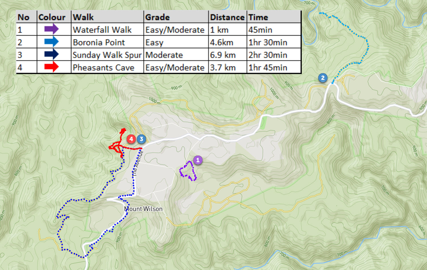
The Waterfalls Walk
- Details
Approximate time is one hour from the Waterfall Reserve picnic ground, or one and a half hours from the Study Centre. This walk is a must for visitors to Mount Wilson. It is steep with some steps.
Start in the Waterfall Reserve opposite Chimney Cottage. With your back to Chimney Cottage veer to the left across the picnic ground and you will soon pick up the track. A delightful rainforest walk down to the Waterfall Creek. A little steep but well worth it. This is a true rainforest: sassafras, giant coachwood, corkwood, treeferns. The waterfalls are viewed as you walk up Waterfall Creek. The first waterfall is like a little grotto with moss-covered rocks and is a wonderful place to sit on a hot day. The track follows the stream up to the bigger falls where the water tumbles down the basalt cliff. Continue on and up and soon return to the picnic ground.
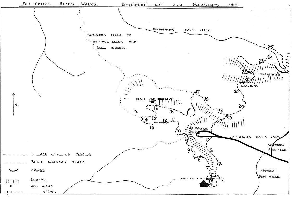
Du Faurs Rock & Chinaman's Hat
- Details
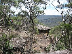
Chinaman's Hat formation south of Du Faurs Rocks
Approximate time for this is half an hour to Du Faurs Rocks or three quarters of an hour if Chinaman's Hat is included. The road is not bitumen and the return is rather steep.
Add another half hour if doing the second section of the walk around the base of the cliffs to the Pheasants Cave track.
Take the road to Du Faurs Rocks which starts beside the fire station. From the Rocks Lookout you can see across the wilderness to Bell. The Wollangambe River, Du Faur and Bell Creeks drain the valley in front of you. From Du Faurs Rocks you can follow the track that wanders south along the top of the cliff to Chinaman's Hat. Note the Aboriginal markings on the rocks where they sharpened their tools and made little grooves for the water to run. It is wonderful to sit on Chinaman's Hat and enjoy the quietness and the view part of the Wollangambe wilderness area.
From here - the second section - there is a lovely walk below the cliffs (30 minutes). It joins the Pheasants Cave walk and there is a wonderful weather worn cave along the way, and lovely views.
-
Caption
Pheasants Cave
- Details
Allow at least an hour for this walk, plus some extra time to spend in this charming cool bower. There are quite steep on part of this bush walk and it is a rough track
This is a magic place! The walk to the Pheasants Cave is commenced from the northern side of Du Faurs Rocks, or continue from Chinaman's Hat. The track leaves the road about 40 metres back from the lookout. This track joins a path below Du Faurs Rocks from Chinaman's Hat, and when you meet it you turn right (east). A path has been cut into the rocks and is well marked. The walk onto Pheasants Cave is well marked, lovely but rather steep. Once down to the stream, cross it and turn right until you come into a small rainforest area where the water falls over the edge of the rocks. The cave is beyond the fall and has been frequented by lyrebirds or pheasants. The stream has its origin in the grounds of the Study Centre.
The Fire Trail around the Study Centre
- Details
This walk takes about 40 minutes. While the fire trail has been well graded it only has a natural surface and is muddy in wet weather. It is a little steep in places.
Walk down the road to Du Faurs Rocks. About two thirds of the way down, the fire trail leads off to the right. There is a locked gate before the creek crossing and one can walk around this.
Follow the fire trail up the hill till it crosses another fire trail. Just before the Wollangambe sign turn right and return to the War Memorial and the Study Centre.
Wynnes Rock
- Details
Allow one hour for this level walk. It's along a made road and is suitable for any weather.
Walk down the road toward the highway and take the second turn on the left into Queens Avenue. Wynnes Rocks Road turns off to the right about 300 metres along Queens Avenue. Follow the road out to the lookout. There is a superb and unusual view south across Bowen's Creek to the Blue Mountains towns and Mounts Tomah, Hay and Banks.
Return on the same road, or turn right into Queens Avenue which becomes Wyndham Avenue and brings you out near the Study Centre (See The Avenue, Queens Avenue, Wyndham Avenue circuit).
Galwey Lane to Picnic Ground
- Details
You will need at least two hours for this if you walk both ways. You might be able to drive a car to the picnic ground to speed up the return.
Walk on the Village Walk via the Church and Wynstay T intersection to Rimon (see the Around the Village walk). Opposite Rimon the track leads through the bush beside the Wynstay fields. If you look up across the fields you can see the back of the old stables and the lovely domed brick well which was built in 1880.
Continue just past Merry Garth and at the corner of the lane (in the dip) you will see steps to your right and a track which takes you through the rainforest behind Campanella and Linden, coming out at the end of Hillcrest Lane which is grassed and comes down on the left.
Keep beside the fence of Tolimount Cottage and walk along past Bisley. Just past Bisley the road ends at a gate. Stay to the left of the gate and the path takes you into the back of the picnic ground (the tracks divide, but they all end up at the Picnic Ground). You can return along Hillcrest Lane, then either walk along the Anniversary Walk and the Village Walk, or go down Davies Lane and through the bush to Waterfall Road. If you want a longer walk go back by the fire trail (see the Cathedral Picinic Ground to the Study Centre walk).
Lambs Hill East
- Details
Allow thirty minutes for this walk and an extra fifteen minutes to walk out along the old road.
From the track above the Cathedral of Ferns go straight ahead where the track swings to the left and follow the power lines down to the Happy Valley picnic area.
From Happy Valley picnic area, go along the old road to the left. Here there are glorious views of the wilderness area. You can return from Happy Valley through Lambs Hill or along the main road (which is through some lovely rainforest). Please take care when walking on the narrow road Mt Irvine Rd.
Cathedral of Ferns walk
- Details
From the Cathedral Reserve Picnic Ground it only takes about 10 minutes to walk through to the Cathedral of Ferns. It is another must for all visitors to Mount Wilson. Allow half an hour to do the complete walk. The Cathedral walk is lovely in the mist. On a warm summer evening there are often fire flies in this area, just on dark.
Starting at the Picnic Ground, walk into the Cathedral of Ferns and watch out for the Giant Tree. This is a massive Messmate or Fastigata, which was sadly hit by lightning recently and has died. Wander up beyond it and the path will come out on a track. Turn right here onto the track, but then keep to the left all the time. Go through a gate with a hole in it (not the 'private property' one). Keep to the left track until you come back near to the Picnic Ground. There are lovely wild flowers here in October and November.
Cathedral Picnic Ground to Study Centre
- Details
Allow three hours for the walk one way along the Northern Fire Trail.
From the Picnic Ground find the fire trail near the lower corner beside the tree plantings (Metasequoia). There is a locked gate and, as you are walking through private property, please keep to the fire trail. It goes to the left and down. This is the Northern Fire Trail and wanders below the houses and eventually comes out near the Study Centre. It is a good bush walk with a variety of vegetation and some nice views to the north and a long uphill section.
Zig Zag, Sunday Spur Walk
- Details
Allow one hour for this walk from the Study Centre.
From the Study Centre, walk down toward the Zig Zag. About 150 metres before you reach the corner you will see a little track on your right. This takes you up onto Sunday Walk Spur. Follow the track beside Breenhold fence, which is on your right. When the fence ends you will see the fire trail. Turn right and follow this below Breenhold and back to the Du Faurs Rocks Road. There are good northerly views and interesting rock formations. A very good short walk.
Walford Lane Walk
- Details
This is a relatively new walk, upgraded in mid 2010 when Integral Energy cleared for vehicular access underneath power lines. It is not included in Libby's original Walks booklet.
For those who like to walk around the village, you can now walk along Walford Lane (off Waterfall Road) between Rimon and Chimney Cottage beneath the power lines. Please close all the gates behind you.
This track leads to the bottom end of Applecot Lane. Take a sharp turn to your left into Applecot Lane, again beneath the power lines, cross over the creek and make your way up the lane to Wyndham Lane. This walk can of course be done in either direction.
