- Details
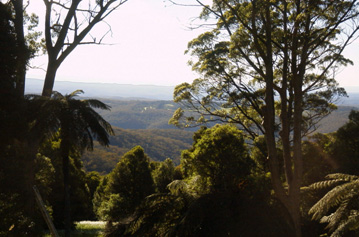 Mount Wilson and, nearby, Mount Irvine, are two basalt capped peaks on the northern edge of the Blue Mountains. Blessed with rich volcanic soils, these two peaks were heavily timbered with temperate rain forests of sassafras, coachwood, lilli pilli, tree ferns and a thick understorey of ferns. The forests are teeming with wildlife and birds.
European settlers had difficulty reaching Mt Wilson and Mt Irvine, however there is much evidence that indigenous people camped in the area. There are many rock carvings and paintings, implement-sharpening grooves, and stone axe-heads to be found among the caves and forests, and chips of chert, a rock not of this district, have been found along creek banks.
William Romaine Govett surveyed the area in 1832-33, producing a plan of the area north of Bell’s Ridge which shows but does not name the Wollangambe River and Bowen’s Creek. Between them is a ridge marked “High mass of the range of the richest soil covered with the most impenetrable scrub.” This was Mt Wilson. Govett crossed the western end of the Mt Wilson ridge (see NSW Railway Guide of 1879). Following an exploratory trip by George Barton Bowen from Berambing, Edward S Wyndham, directed by Philip Francis Adams, Deputy Surveyor General of NSW, surveryed the ridge in 1868.
The area was named Mt Wilson in honour of John Bowie Wilson, member of the Legislative Assembly in NSW and the Minister for Lands. Wyndham drew up a plan of 62 portions (covering the baslat areas) ranging from 7 to 45 acres. Only one portion was sold before the Mt Wilson Platform (later to become Bell station) was built in 1875 where the Bell’s Line of Road crosses the railway line at Bell. The sale of all 62 portions was then completed by 1876.
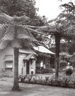 By 1880, eight houses had been built for use as retreats from the summer heat of lower altitudes, creating at what was known at the time as a 'hill station'. Many of these early landholders had made their mark already on NSW society, business and government. While laying out their extensive gardens in the rich volcanic soil, they never lost sight of the magnificent environment of luxurious native rainforest and bushland which surrounded them at Mt Wilson. Eucalypts and tree ferns are still featured among the exotic trees and shrubs which make Mt Wilson famous as a ‘heritage garden village’.
Those early settlers included Lewis Thompsom, a protege of Eccleston Du Faur, a foundation member of the NSW Academy of the Arts, later President of the NSW Art Gallery, and responsible for the establishment of Kuringai Chase; and Richard Wynne, first Mayor of Burwood and benefactor of the Wynne Art Prize for Landscape who bought several of the original portions. Thompson acted as a caretakre, servant, maintenance man and provider for the early settlers of Mt Wilson. Three grandsons of William Cox, who built the first road over the Blue Mountains, were also among the first landholders, and GH Cox’s property ‘Beowang’ (now Withycombe) was purchased in 1921 by Mr & Mrs V. White, parents of Nobel Prizewinning author Patrick White, who spent time there as a boy. Two other signficant settlers were Edward C. Merewether of the Australian Agricultural Company and Jesse Gregson, who replace replaced Merewether as Superintendent of the same company.
Not only did these and other settlers establish extensive gardens but they also planted the magnificent avenue of trees from Sefton to Wynstay Lodge. They built the School in 1891 and later St George’s Church, built as a memorial to Henry Marcus Clark by his children, and consecrated in 1916. Land was donated for Founder’s Corner, a sports ground named Silva Plana, and almost 3000 acres of native bushland, including rainforest, was placed in Crown Reserves.
Mt Wilson remains a fascinating and charming village with many English-style houses, gardens and avenues, now over one hundred and thirty years old, in a setting of Australian bushland and rainforest.
Mt Irvine was developed later; in 1897 Charles Robert Scrivener, a staff surveyor of the Lands Department, was given the job of surveying a road to the end of the Mount Wilson spur. He described the land there and located an approach across Bowen's creek, to Bell's Line of Road near Bilpin. He suggested that it should be proclaimed a national reserve, but instead it was thrown open for settlement and called Mt Irvine.
The men who took it up were C.R. Scrivener's son, Charles P. Scrivener and two of his friends, Harold Morley and Basil Knight-Brown. These three young men had graduated with credit from the Hawkesbury Agricultural College in 1897, the first year of Mr George Valder's tenure as principal. They each selected 10 hectares, and developed orchards, dairy and vegetable growing. Their chief problem was access, and for twelve years, each worked on the road to Mount Irvine for one month each year.
For further reading, Ian Jack has written a well researched article about the early history of Mt Wilson and Mt Irvine.
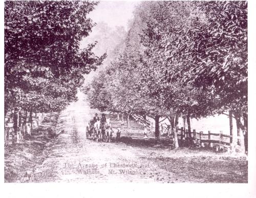
Above is an early view of The Avenue, Mt Wilson, taken from a postcard of the day.
